
The Rivers

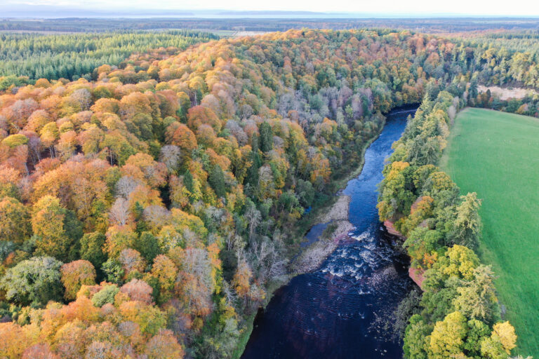
The Findhorn, Nairn and Lossie Rivers are situated in Moray and the Highlands, a central region in our project area. The River Findhorn is the largest catchment and one of the longest rivers in Scotland. It is popular with anglers from around the globe and is also one of Scotland’s classic white water kayaking rivers, drawing canoeists from across the country.

In addition to the River Findhorn this catchment includes the Muckle and Mosset burns, which are both significant water bodies in our invasive plant control programme. These burns run into Findhorn Bay, one of the largest non-firth estuaries in Scotland.

Findhorn Bay is designated as a Site of Special Scientific Interest (SSSI), Special Protection Area (SPA) and Ramsar Site. Lower Findhorn Wood on the lower reaches of the Findhorn is also a designated site (SSSI, Special Area of Conservation) for it’s ancient woodland, bryophyte and lichen assemblages while Randolph’s Leap (SSSI) is a notable site on the River for it’s geological features. There are many other designated sites across the three catchments including Loch Ruthven, Loch Spynie and Buinach and Glenlatterach Woodland.

Our project partner for the catchments is The Findhorn, Nairn and Lossie Rivers Trust. The Trust has been tackling invasive species in the catching for many years, starting work locally before the Initiative began.

The Findhorn, Nairn and Lossie Rivers

The River Nairn

The River Nairn is located in the Highlands, south east of Inverness. It rises near Carn Ghriogair in the Monadhliath Mountains and flows north east for 58 km (36 miles) to meet the Moray Firth at the town of Nairn. The main tributaries are the River Brin, River Farnack, Craggie Burn and Cawdor Burn. Loch Duntelchaig is the only major loch in the catchment. The Nairn is a rural river, flowing through mountains, moorland and farmland, with an overall catchment size of 313 km² (121 square miles).

The River Findhorn

The River Findhorn is one of the longest rivers in Scotland, flowing 100km (62 miles) from it's source in the the Monadhliath Mountains to meet the Moray Firth at Findhorn Bay. The Findhorn passes through Tomatin, Dulsie, Forres and Findhorn village on it's way north east through Moray. The River Divie is a main tributary, while the Muckle and the Mosset Burns also run into Findhorn Bay. The catchment covers an area of 1,300 km² (500 square miles) and includes areas of open moorland, peatland, forestry and agriculture.

The River Lossie

The River Lossie rises from Loch Trevie, in the hills above Dallas village, and flows 52 km (31 miles) north east through Moray. It passes through Kellas and Elgin before meeting the Moray Firth at Lossiemouth. Its main tributaries are the Auchness, Yellowbog, Corrhatnich, Leanoch, Gedloch, Linkwood, and Black Burns; the Lhanbryde Burn and Spynie Canal are also part of the catchment. In total, the catchment area covers 216 km² (83 square miles) and the majority of land use is agriculture and forestry.

Our Activities

Click the expandable sections to find out more about our plant control activities; information on American mink is listed below.

Giant hogweed is controlled in all three catchments in collaboration with land owners, land managers and volunteers.

On the River Nairn giant hogweed is controlled from source-to-sea. The problem begins at Clephanton on the Nairn, with a secondary infestation on the Auldean Burn. There is also an isolated patch off-river at Cantraydoune which we are controlling to prevent infestation of nearby burns.

On the River Findhorn infestations are limited to the main stem of the river; the upstream source is at Logie Bridge. We are currently controlling down to the A96, just outside Forres. We are also treating separate infestations on the Muckle Burn, from Feddan Farm to Dyke, and on the Mosset Burn, from source (Altyre Estate and Sourbank) to sea.

There are significant giant hogweed infestations on the River Lossie. Our work begins at Kellas, the upstream source, with our current downstream limit at Palmerscross, just outside Elgin. No work currently takes place below this point.

Japanese knotweed is controlled in all three catchments in collaboration with land owners, land managers and volunteers.

On the River Nairn Japanese knotweed is under management from the source of the infestation (Cantraydoune) down to the sea. Infestations are present in sporadic patches.

On the River Findhorn we are currently treating from the upstream source at Ardclach down to the A96 bridge. In this area infestations are present in sporadic patches. There are significant infestations downstream of the A96 and on the Muckle burn; this is not yet within our control programme.

In the Lossie catchment we are controlling Japanese knotweed from the upstream source at Kellas down to Palmerscross, just outside Elgin. In some areas there are really significant outbreaks, with large infestations extending hundreds of metres off the river banks.

Himalayan balsam is widespread throughout the Findhorn, Nairn and Lossie catchments.

This year (2025) we will begin to target the source on the Nairn, just upstream of Cawdor, in collaboration with volunteers and local estates. In previous years we have worked with community groups to tackle infestations around the town of Nairn.

We are not currently controlling this species in the Findhorn or Lossie catchments.

Himalayan knotweed is a very localised problem in the Findhorn catchment near Forres. We believe we are controlling the full extent of the infestation. Please notify us if you see this species present anywhere in the Findhorn, Nairn or Lossie river catchments.

American mink

The Findhorn, Nairn and Lossie Rivers present mixed and sometimes challenging habitats for our mink control project. There are coastlines and agricultural areas in the lowlands, which both provide good habitat for mink, and open hills and moorlands in the highlands, where mink are still present but in lower densities.

The River Findhorn presents particularly challenging areas to monitor and trap; there are many steep valleys and gorges in the middle of the catchment which are difficult to access and prone to high floods when the river is in spate.

Currently (spring 2025) we have 53 active mink rafts and traps monitored by a network of 33 dedicated volunteers, with a few additional traps covered by the project team.

Meet your local Project Officer

Elise first started with us on a student placement through her degree with the University of the Highlands and Islands. In 2021 she started working with us as a Seasonal Project Officer for the Spey, Findhorn, Nairn and Lossie catchments and in autumn 2022 she took on the role of Project Officer for this area. In Phase 2 of the project (2023-2026) she moved over to the Findhorn Nairn and Lossie catchments full time.

Elise co-ordinates plant control activities and oversees the mink trapping network across the Findhorn, Nairn and Lossie River catchments. If you are a landowner, land manager, community group or local organisation in this area and would like to get involved in the project, please get in touch.

Tel: 07880971890
elisecox@fnlrt.org.uk

Volunteering Opportunities

Find out more about volunteering opportunities available in the Findhorn, Nairn and Lossie River catchments. You can also visit our Volunteering page to find out about opportunities available across the project and for further details on these activities.

Sign up to volunteer

If you are interested in volunteering please complete the online registration form. Your local contact will then be in touch.