Summary
The Stuartfield Burn is a tributary of the South Ugie Water running through the village of Stuartfield in Aberdeenshire. In 2018 the site was identified as the most upstream point of giant hogweed on the burn and a potentially significant seed source of giant hogweed infestations downstream to the South Ugie Water. Giant hogweed had become established around Stuartfield and was outcompeting native vegetation, increasing the risk of bank erosion, and posing a human health hazard. Control was needed to prevent further spread of the plant around the village and limit seed dispersal into the South Ugie Water.
Working with landowners and volunteers, the Scottish Invasive Species Initiative has managed giant hogweed control at this site from 2018-2025. Approximately 2.2km of river length was covered, totalling 4.4km of riverbank. This work has significantly reduced the abundance of giant hogweed on the site and, consequently, the time and chemical volume necessary for annual control.
In 2025, as in previous years, the upper section of the burn was controlled by land managers while project officers filled in the gaps through the village and further downstream where landownership is fragmented. Project staff will continue to monitor the whole site, provide advice and support when needed, and control the lower sections. Encouraging progress has been made but monitoring and control work will be needed for several years to fully exhaust the seedbank, eradicate the plant, and prevent further spread of seeds downstream into the South Ugie Water.
1. Site description
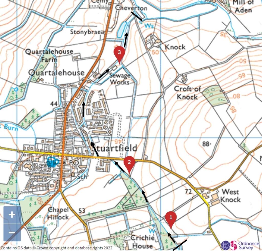
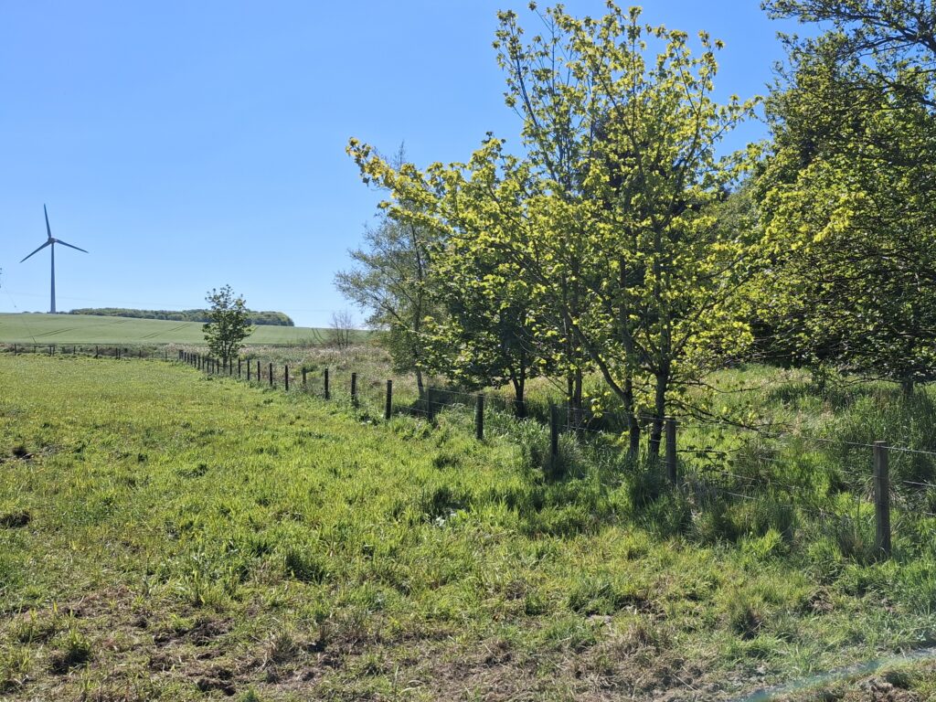
The Stuartfield Burn site is a 2.2km stretch of burn running through Stuartfield village in Aberdeenshire (see Map 1 below). Land use is varied along the banks and includes residential gardens, pastures, unimproved grassland and conifer plantation.
The upper limit of the site starts above West Knock Farm (grid reference: NJ 98144 45195) and ends at the confluence with the South Ugie Water (grid reference: NJ 97910 46830). Ownership is shared by a number of individuals – with no single owner having overall responsibility of the site. In total, giant hogweed has been controlled on approximately 4.4km of riverbank, covering both banks of the 2.2km river section.
Within the Scottish Invasive Species Initiative partnership, the Ugie catchment is covered by the Deveron, Bogie and Isla Rivers Charitable Trust.
Map 1 – Location of giant hogweed control site on the Stuartfield Burn with monitoring points shown in red
2. Background
This site marks the uppermost extent of giant hogweed on the Stuartfield Burn and is one of the key seed sources for the South Ugie Water. The origin of the plant is unknown, but it may historically have escaped from a garden and/or been spread by agricultural activities. It is now present at several locations downstream and is well established in the catchment.
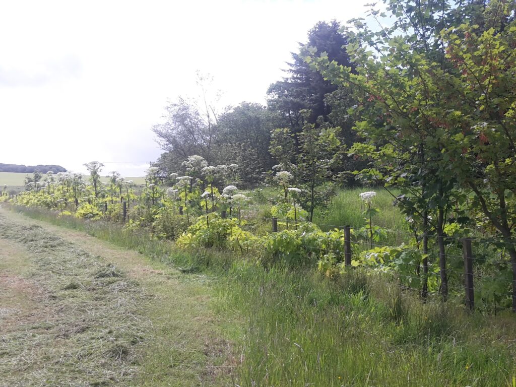
The Stuartfield Burn site was identified for control by the Scottish Invasive Species Initiative in 2018 and the site was further extended upstream in 2019. At that time giant hogweed was present throughout the site – being the most abundant species in some areas and growing alongside native vegetation elsewhere. In the worst areas, giant hogweed was outcompeting other ground flora and leaving banks vulnerable to erosion when winter dieback exposed bare soil. If left untreated the plant was likely to become dominant in already established locations and spread further downstream to less affected areas.
After the Scottish Invasive Species Initiative alerted them to the issue – highlighting the importance of tackling infestations and preventing further spread downstream – two major landowners agreed to work with the project to control plants on their land. In other areas, control has been carried out by project staff and volunteers.
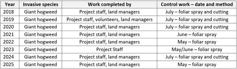
3. Management works
Giant hogweed was first treated on the site in 2018, followed by annual control from 2019-2025. Initially, control started one pasture above Stuartfield village and continued downstream to the confluence with the South Ugie Water. In 2019, additional giant hogweed plants were found further upstream and so the site boundary was extended to include these. The landowner was alerted to the discovery and agreed to carry out control.
Two control methods were used – foliar spraying and manual cutting of flowering heads to prevent seeding. Manual cutting was combined with herbicide application (to remaining leaves and into hollow stem) to prevent regrowth. Table 1 (below) shows a summary of the control treatments.
Table 1 – Summary of giant hogweed control treatments on Stuartfield Burn (2018 – 2025)
4. Results
4.1 Invasive species abundance
Monitoring was undertaken at six representative points within the site from 2018/2019 to 2025. The abundance of giant hogweed was measured using the DAFOR scale*. Recorded abundance of giant hogweed at these points is shown in Table 2 below.
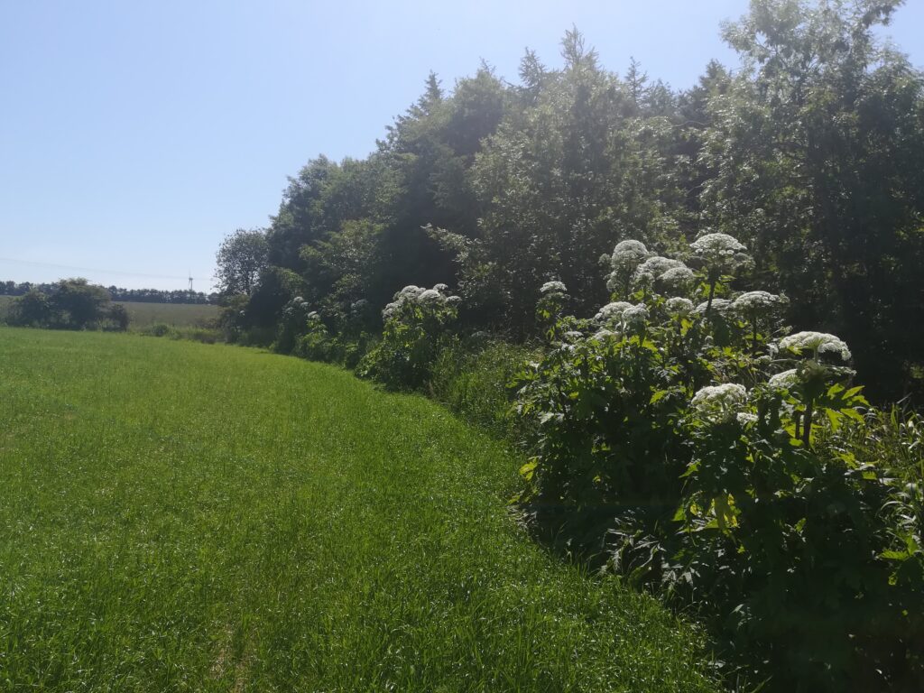
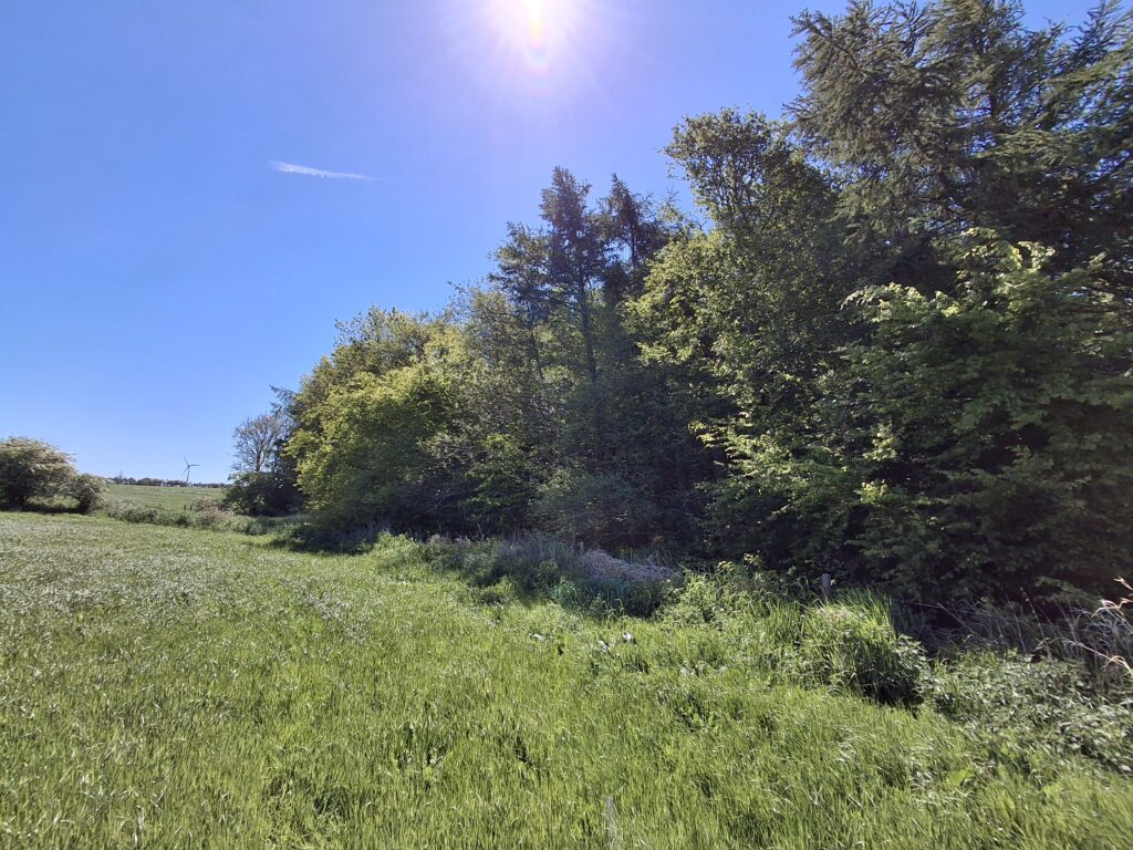
Before control work, the abundance of giant hogweed was either ‘dominant’, ‘abundant’ or ‘frequent’. Over several years of treatment, a reduction in abundance was observed at all monitoring points. By 2025 abundance had reduced to ‘rare’ or ‘none’ at five monitoring points and ‘occasional’ at one. This is shown by the recorded abundances in Table 2 at monitoring points and fixed-point photography (see Figures 1a, 1b, 2a and 2b below).
Table 2 – Annual giant hogweed abundance from DAFOR* surveys (2018 – 2025) at Stuartfield Burn. Note: The infestation at point 1 was not discovered until 2019 and point 3 not monitored until 2019.
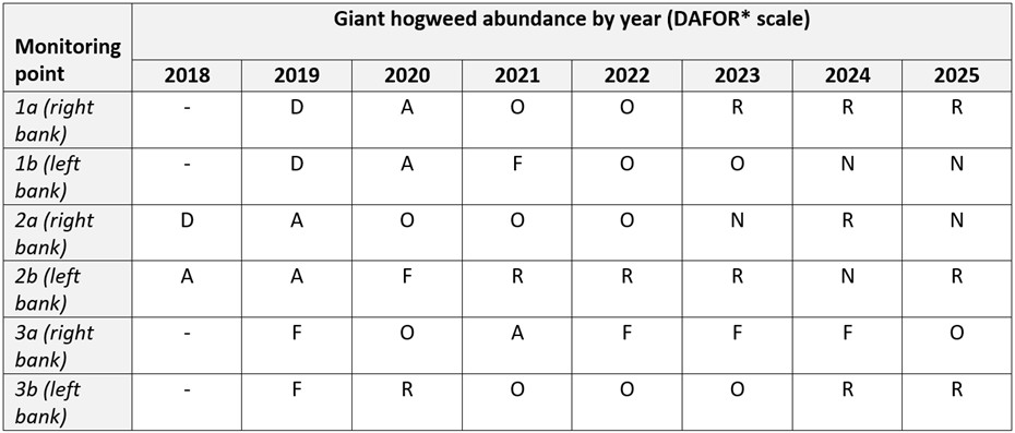
* – DAFOR Scale of abundance – D = Dominant (50 – 100% cover), A = Abundant (30 – 50% cover), F = Frequent (15 – 30% cover), O = Occasional (5 – 15 % cover), R = Rare (<5% cover), N = Not Present (0%)
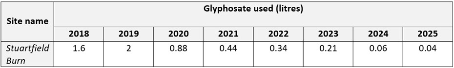
4.2 Chemical usage
In each year of treatment, glyphosate (RoundUp Provantage 480mg/l) was applied by knapsack sprayer at a concentration of 20ml per litre. The volume of glyphosate used each year is shown in Table 3 below.
The increase in glyphosate used in 2019 was due to the discovery and treatment of a new area. Following this, chemical volume decreased each year.
Table 3 – Volume of glyphosate used to control giant hogweed at Stuartfield Burn (2018 – 2025)
4.3 People effort
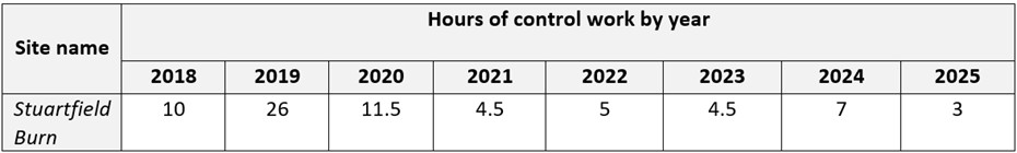
Control work was carried out by landowners and by Scottish Invasive Species Initiative staff and volunteers. Table 4 (below) shows the people hours required to control giant hogweed each year. The increase in hours spent on control in 2019 was due to the new area of giant hogweed that was discovered and treated in that year – this area was not part of the work programme in 2018.
Control hours decreased substantially from 2019 to 2021 and have fluctuated since then. In 2023, due to staff turnover, landowner hours were not recorded and so are missing from the records for that year. Hours increased slightly in 2024 as new staff, unfamiliar with the area, spent more time searching for the few remaining plants at the site. In 2025, only 3 hours were spent on control work.
Table 4 – People hours needed to control giant hogweed at Stuartfield burn (2018 – 2025)
5. Conclusions and Progress Made
Control measures taken along the Stuartfield Burn since 2018 have reduced giant hogweed abundance at the site and the time and chemical volume required for annual control.
A significant reduction in abundance was observed at the monitoring sites from 2018 to 2025 (see Table 2 and Figures 1a, 1b, 2a and 2b). Giant hogweed was recorded as ‘rare’ or ‘none’ at most monitoring points in 2024 and 2025, following annual control since 2018/2019 when it was recorded as ’dominant’, ‘abundant’ or ‘frequent’.
The time and chemical volume required for control reduced from 2019 onwards, after the upper source of giant hogweed was discovered and included in control efforts (see Tables 3 and 4). Chemical volume and hours spent on control reduced by 98% and 92% respectively between 2019 and 2025.
This is positive and significant progress; consistent annual control has substantially reduced giant hogweed abundance. Control may be required at the site for a number of years to fully exhaust the seedbank but giant hogweed abundance has been substantially reduced. Ongoing efforts have prevented flowering plants adding to the seedbank and spreading additional seeds further downstream and into the South Ugie Water where treatment is ongoing at other sites. Promising recolonization of native flora has been observed in many of the sites which will hopefully help to suppress the emergence and growth of any giant hogweed seedlings.
6. Next Steps
Giant hogweed seedlings may emerge at the Stuartfield Burn site in 2026, and in subsequent years, if the seedbank has not yet been fully depleted. Giant hogweed seeds can persist in the soil for up to 10 years; it is therefore likely that a depleted seedbank remains at the site. In this case, annual treatment will continue. If no hogweed emerges the site will be moved into a ‘monitoring’ phase for several years to ensure no giant hogweed plants are able to mature and set seed, which would replenish the seedbank once more. In time, any remaining seedbank will be diminished and then exhausted at the site.
In 2026, the site will be monitored by project staff and, as in previous years, land managers will control the upstream section. One has signed a Voluntary Control Agreement with the project and we have verbal agreements with the other land managers. The project will continue to support all land managers as they control and monitor the upstream sections. As landownership is very fragmented through the village and further downstream, project staff will continue to undertake control work on the lower sections of the site. Giant hogweed abundance has been reduced to such an extent that this work can be completed in a couple of hours.
Further information
Contact: sisi@nature.scot